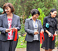
Second Phase of the "Berlin Process" launched at "Blue diplomacy in Central Asia" conference

After four successful years of the Central Asia Water Initiative (the Berlin Process), German Foreign Minister Guido Westerwelle invited government representatives from Kazakhstan, Kyrgyzstan, Tajikistan, Turkmenistan and Uzbekistan to the two-day conference „Blue diplomacy in Central Asia”, taking place in Berlin, 7-8 March 2012. The participants took stock of the activities undertaken during Phase I of the Berlin Process and outlined the activities planned for Phase II sending a strong message: the political will exists to continue cooperating on transboundary water management in the region.
CAWA Technical Training "Installation, Operation and Maintenance of CAWa HyMet Hydrometeorological Monitoring Stations"
From December 5th to 9th, 2011, a technical training on installation, operation and maintenance of CAWa HyMet Hydrometeorological Monitoring Stations was hold at GFZ in Potsdam. The CAWa project invited 10 specialists from Afghanistan and Tajikistan to participate in the training.
CAWa Training "Climate Change Impact Assessment and Hydrological Modelling"
From December 12th to 16th, 2011, a training course with focus on hydrological modelling was hold at GFZ in Potsdam. The CAWa project invited 17 specialists of the Central Asian hydrometeorological services, research institutions and water management organisations to participate in the course. This course was organized in cooperation with United Nations Development Program (UNDP) Central Asia Climate Risk and Mitigation Programme, Uzbek Hydrometeorological Service and the University of Würzburg.
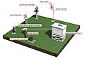
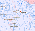
Official inauguration of the regional Hymet monitoring network in Bishkek
On Friday, 16 September 2011, GFZ and CAIAG presented the first part of the regional hydrometeorological monitoring network being established in the frame of the CAWa project. Representatives of the German Federal Foreign Office, the Ministry of Foreign Affairs of the Kyrgyz Republic, as well as the Kyrgyz Ministry of Emergency Situations participated in the official inauguration ceremony which was held in Bishkek.
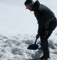
Climate and glacier monitoring at Abramov glacier resumed
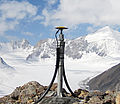
In the end of August 2011, a multi-national team of researchers went on expedition to the Abramov glacier in the Alai range, Southern Kyrgyzstan. The team installed a CAWa Hymet monitoring station near the glacier, performed initial GPS measurements on the glacier and installed ablation stakes. With these activities, climate and glacier monitoring is being resumed at Abramov glacier, where a permanent research station had been operated until summer 1999 when it was destroyed by a local guerilla group.
Glacier monitoring in the Tian Shan Mountains continued
Following last year’s expeditions, a group of Kyrgyz, German and Swiss scientists continued the fieldwork on three selected glaciers in the Tian Shan mountains in Kyrgyzstan. The expedition team included researchers from the GFZ German Research Centre for Geosciences, Central Asian Institute of Applied Geosciences (CAIAG), University of Fribourg and the World Glacier Monitoring Service WGMS.
CAWa Training Course "Remote Sensing for Land Use and Land Cover Mapping"
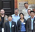
From 15th - 19th August 2011 thirteen academics from water management organisations from the region Central Asia met to participate in a training course at the German Research Centre for Geosciences (GFZ) in Potsdam, Germany. For the first time including two colleagues from Turkmenistan. The training course took place in the GeoLab, the training and education facility of GFZ. Organizers were GFZ in cooperation with the University of Wuerzburg Institut of Geography and Geology, Department of Remote Sensing.
German and Uzbek researchers collect land use data in Fergana Valley
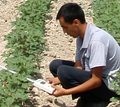
Scientists from the University of Wuerzburg, SIC ICWC and ZEU had an expedition to Fergana Valley in June 2011. They collected reference data on agricultural fields needed for the evaluation of land use classifications derived from remote sensing data. Besides, measurements of the biophysical parameter Leaf Area Index (LAI) were carried out. The expedition was supported by the German fiat panis foundation.
Rapid Eye satellite data used for research on irrigation monitoring
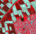
A research proposal of the University of Würzburg has been approved by the RapidEye Science Archive in March 2011. RapidEye will provide very high resolution satellite data (6.5 m) for three irrigated agricultural areas in Central Asia (Ferghana valley, Amudarya Delta, Kyzyl Orda) for the growing period in 2011 and 2012.
Web GIS with Central Asian geodata online
The demonstrator version of a web GIS with geodata on Central Asia is online accessible at http://gdbweb.caiag.kg/. The web GIS and the linked geodata base have been developed by specialists of the Central Asian Institute for Applied Geosciences CAIAG.