Climate and glacier monitoring at Abramov glacier resumed
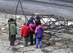
In the end of August 2011, a multi-national team of researchers went on expedition to the Abramov glacier in the Alai range, Southern Kyrgyzstan. The team installed a CAWa Hymet monitoring station near the glacier, performed initial GPS measurements on the glacier and installed ablation stakes. With these activities, climate and glacier monitoring is being resumed at Abramov glacier, where a permanent research station had been operated until summer 1999 when it was destroyed by a local guerilla group.
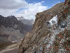
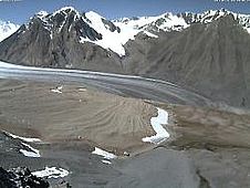
The former research station at Abramov glacier
Located at the divide between the Syrdarya, and Vaksh river basins, the Abramov glacier is considered a key indicator for water resources in both main river basins of Central Asia, the Amudarya and the Syrdarya. Continuous monitoring of climate and glacier parameters started in the 1960ies. In 1968, a permanent research station had been established, which in its’ best times hosted up to 67 scientists. From this period, more than 30 years of observational data are available providing a unique data set for the characterization of the cryosphere and the assessment of its’ changes over the past decades.
In August 1999, the station was destroyed by armed fighters of a local terror group, and glacier monitoring had not been continued since.
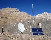
The new Abramov glacier station
12 years later, scientists from GFZ and CAIAG in close cooperation with researchers from UzHydromet, the Universities of Fribourg and Zurich in connection to the World Glacier Monitoring Service, and the Tajik Academy of Sciences, installed a new climate station at Abramov glacier, thus resuming continuous monitoring.
Video about the installation works (mp4-file, ca. 50 MB, 5:30 min)
The new automated monitoring station is located at an altitude of 4,100 m a.s.l., around 1 km linear distance from the location of the former research station. The station was put into operation on 30 August 2011 and measures the following parameters:
Station | Abramov glacier |
Coordinates | 39° 38’ 55" N, 71° 35' 09" E |
Elevation | 4,100 m a.s.l. |
River basin | Vakhsh river |
Start of operation | 30-Aug-2011 |
Sensors: |
|
GPS | + |
Air temperature | + |
| Relative humidity of air | + |
Atmospheric pressure | + |
Rain gauge | + |
Snow pack analyzer | + |
Wind monitor | + |
Solar radiation | + |
Soil water content | + |
| Soil temperature | + |
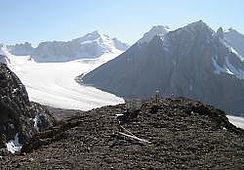
In addition, specialists of the World Glacier Monitoring Service installed 2 cameras to monitor the snow line and determine the equilibrium line of Abramov glacier which separates the ablation and the accumulation zones.
The station data is usually transmitted once a day to the CAWa System Operation and Processing Facility (SOPAF). It can be accessed using the CAWa station monitor and downloaded using the Export Observations functionality.
The Abramov station is the 4th station installed in the frame of the CAWa project in Kyrgyzstan. The three other stations are Baitik, Kokemeren and Taragay.
The station installation works at Abramov glacier were funded by the German Federal Foreign Office in the frame of the CAWa project. The German Federal Ministry for Education and Research / International Bureau as well as the Swiss Agency for Development and Cooperation provided co-funding for travels and the camera system.
Submitted by Katy Unger-Shayesteh on