New land cover products for Central Asia
Within the CAWa project, the team of the Land Surface Dynamics working group at the German Aerospace Center DLR/DFD has elaborated a set of new remote-sensing based, multi-temporal land cover products for the region of Central Asia. The products include (1) a land cover classification for the years 2001 and 2009, (2) water bodies for the period 2000-2010, (3) net primary productivity for Kazakhstan for the period 2003-2011, (3) daily snow cover for the period 2000-2011, and (4) a soil moisture product. The new data sets are the basis for current and future research activities focusing on change detection and the effects of atmospheric and terrestrial processes on land cover.
Regional Land Cover and Land Use Classification
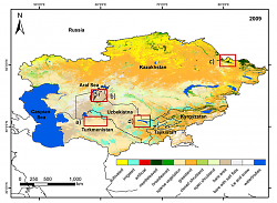
In Central Asia major alterations in land use and land cover occurred in the past decades due to political collapse of the Soviet Union, human forces, and climate change. Here we performed a classification approach with implemented C5.0 decision tree algorithm addressing regional land cover characteristics of Central Asia. The classification is based on season features derived from MODIS (Moderate Resolution Imaging Spectroradiometer) time-series and was performed for the years 2001 and 2009. Both classifications show an overall accuracy above 90% as determined based on 1/3 of the collected reference samples, which were not used in the C5.0 training process.
The results show some significant changes between both years in different land cover classes: (1) Human induced alterations of water bodies, (2) variability in sparsely vegetated areas due to seasonal precipitation and (3) forest loss caused by forest fires and logging. Figure 1 shows the result for the year 2009.
For more information see Klein et al., 2012 or contact Igor Klein.
Dynamics of Water Bodies
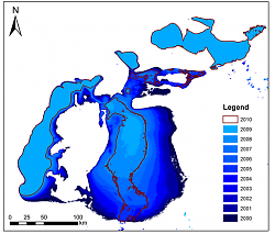
The applied approach for identification of water bodies is based on 250m MODIS NIR data. The approach allows an accurate and independent derivation of water bodies for entire Central Asia with high temporal resolution. The automated process combines information from mean NIR composite of MODIS images between day 186 and day 209 of every year and rescaled SRTM data. The implementation of slope values calculated from SRTM allows a precise identification of water bodies and their actual extent with very high accuracy above 95%.Exemplary water surfaces in Figure 2 reflect the state of Aral Sea for the month July from 2000 to 2010. Nowadays the Aral Sea consists of the Northern Sea (also called Small Aral), the eastern and western part of the Southern Sea (also called Large Aral). The eastern basin of the Aral Sea almost dried out in 2009. However, in 2010 the size of the water surface of the eastern South Sea increased again probably due to higher snow melt.
For more information about water mask in Central Asia please contact Igor Klein.
Net primary productivity for Kazakhstan 2003-2011
The model BETHY/DLR was applied for net primary productivity (NPP) calculation for Kazakhstan for the period 2003-2011. NPP is the dry matter production by green vegetation per unit area and unit time. It provides a quantification of carbon sinks and sources and is a key variable for ecological monitoring activities and a sensitive indicator of environmental change.
The model BETHY/DLR is a soil-vegetation-atmosphere transfer model. It simulates CO2 uptake by vegetation as a process that is limited by light, heat, soil water, and nitrogen. The model is driven by remote sensing data (e.g. Leaf Area Index - LAI, derived land cover) and meteorological input data derived from European Centre for Medium-Range Weather Forecast (ECMWF) (e.g. temperature, precipitation, Photosynthetically Active Radiation – PAR) and calculates NPP with 1 km spatial resolution.
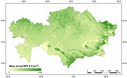
The NPP results obtained with BETHY/DLR were analysed regarding spatial, monthly, and inter-annual variations. Figure 3 shows the mean annual NPP for 2003-2011 for Kazakhstan. The rain-fed agricultural areas in the North and irrigated agriculture in the South of the country are clearly identifiable by their high productivity. The regions that experienced most months with anomalous NPP (i.e. an NPP deviation of at least twice the mean standard deviation above or below the 9-year mean) in 2003-2011 were located in northern Kazakhstan. These regions seem to be more strongly affected by changing climatic conditions or human impact. Percentage variability was lowest in the semi-arid and arid regions covered by open shrubland and grassland. For these regions, NPP modeling may allow prediction of possible carbon sequestration and available biomass for livestock.
Comparisons of monthly NPP deviations to gridded meteorological data sets (temperature, PAR, and precipitation) show that temperature is most critical in spring, while PAR is relevant throughout the year. The reaction of vegetation growth to precipitation is delayed 1-2 months. The results of these analyses may help to identify regions that are more vulnerable to changing climate and support sustainable land management.
For more information about NPP modeling in Central Asia please contact Christina Eisfelder.
Snow cover parameters for Central Asia
Snow cover is a major source of fresh water in Central Asia. Mapping the occurrence, duration and variability of snow cover can help to identify regions with stable snow cover conditions as well as areas where snow is highly variable between different years. Irregular snow cover and spontaneous snow melt can trigger serious disasters such as floods, landslides or droughts. Spatially explicit snow cover information can support modeling of runoff in major river catchments but can also help to understand the influence of climate change on snow cover dynamics. The MODIS sensors aboard the Aqua and Terra satellites are a suitable data source for the analysis of snow cover parameters as they provide daily measurements of the surface in appropriate resolution (~500 m).
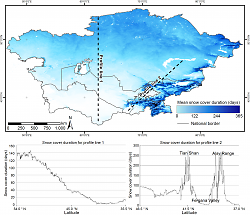
Snow cover duration, snow cover start, and snow cover melt were derived from MODIS data for entire Central Asia since the year 2000. The results depict a distinct dependence of snow cover on both latitude and elevation (Figure 4). In mountainous regions, snow cover duration increases by around four days per 100m elevation while in the northern plains, snow cover duration increases by ten days per 1° latitude.
For more information about snow cover parameters in Central Asia please contact Andreas Dietz.
Soil moisture condition in 2009 led to increased crop yields in Central Asia
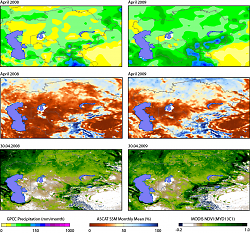
Crop productivity is dependent on availability of an appropriate amount of water and healthy soil condition during the crop life cycle. Rain falling at right time is very important for crop growth especially in rainfed agricultural areas. Microwave remote sensing of soil moisture has been shown to be valuable in many applications including agriculture e.g. crop modeling and irrigation planning. Figure 5 shows monthly averages of soil moisture in April 2008 and 2009 compared to GPCC modelled monthly precipitation and MODIS 16-day NDVI measurements in Central Asia. Soil moisture maps were retrieved from the Advanced SCATterometer (ASCAT) aboard Metap satellite using the TU Vienna change detection method. Unlike the year 2008, an extreme dry year especially in Afghanistan which nearly destroyed the country’s winter grain crop, in 2009 the rainfed wheat was more lush than average (NASA Earth Observatory). Good growing conditions also occurred in Turkmenistan, Uzbekistan, and Tajikistan.
For more information about soil moisture maps for Central Asia please contact Vahid Naeimi.
Опубликовано Katy Unger-Shayesteh в