CAWA Technical Training "Installation, Operation and Maintenance of CAWa HyMet Hydrometeorological Monitoring Stations"
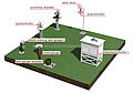
From December 5th to 9th, 2011, a technical training on installation, operation and maintenance of CAWa HyMet Hydrometeorological Monitoring Stations was hold at GFZ in Potsdam. The CAWa project invited 10 specialists from Afghanistan and Tajikistan to participate in the training.
CAWa Training "Climate Change Impact Assessment and Hydrological Modelling"
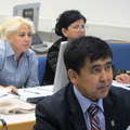
From December 12th to 16th, 2011, a training course with focus on hydrological modelling was hold at GFZ in Potsdam. The CAWa project invited 17 specialists of the Central Asian hydrometeorological services, research institutions and water management organisations to participate in the course. This course was organized in cooperation with United Nations Development Program (UNDP) Central Asia Climate Risk and Mitigation Programme, Uzbek Hydrometeorological Service and the University of Würzburg.
Церемония открытия сети мониторинга Hymet в Бишкеке
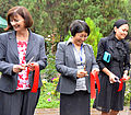
В пятницу, 16-го сентября 2011 г., GFZ и ЦАИИЗ представили первую часть региональной гидрометеорологической сети мониторинга, созданного в рамках проекта CAWa. В официальной церемонии открытия проводимой в Бишкеке присутствовали представители Федерального Министерства Иностранных Дел Германии, Министерства Иностранных Дел Кыргызской Республики, Министерства Чрезвычайных Ситуаций Кыргызской Республики и участники со стран Центральной Азии.
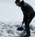
Climate and glacier monitoring at Abramov glacier resumed
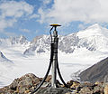
In the end of August 2011, a multi-national team of researchers went on expedition to the Abramov glacier in the Alai range, Southern Kyrgyzstan. The team installed a CAWa Hymet monitoring station near the glacier, performed initial GPS measurements on the glacier and installed ablation stakes. With these activities, climate and glacier monitoring is being resumed at Abramov glacier, where a permanent research station had been operated until summer 1999 when it was destroyed by a local guerilla group.
Glacier monitoring in the Tian Shan Mountains continued
Following last year’s expeditions, a group of Kyrgyz, German and Swiss scientists continued the fieldwork on three selected glaciers in the Tian Shan mountains in Kyrgyzstan. The expedition team included researchers from the GFZ German Research Centre for Geosciences, Central Asian Institute of Applied Geosciences (CAIAG), University of Fribourg and the World Glacier Monitoring Service WGMS.
CAWa Training Course "Remote Sensing for Land Use and Land Cover Mapping"
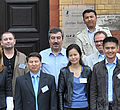
From 15th - 19th August 2011 thirteen academics from water management organisations from the region Central Asia met to participate in a training course at the German Research Centre for Geosciences (GFZ) in Potsdam, Germany. For the first time including two colleagues from Turkmenistan. The training course took place in the GeoLab, the training and education facility of GFZ. Organizers were GFZ in cooperation with the University of Wuerzburg Institut of Geography and Geology, Department of Remote Sensing.
German and Uzbek researchers collect land use data in Fergana Valley
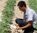
Scientists from the University of Wuerzburg, SIC ICWC and ZEU had an expedition to Fergana Valley in June 2011. They collected reference data on agricultural fields needed for the evaluation of land use classifications derived from remote sensing data. Besides, measurements of the biophysical parameter Leaf Area Index (LAI) were carried out. The expedition was supported by the German fiat panis foundation.
Применение спутниковых данных «Rapid Eye» в исследованиях мониторинга орошения
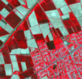
В Марте 2011 года предложение для научного исследования Университета Вюрцбурга было одобрено Научным Архивом «Rapid Eye». «RapidEye» предоставит спутниковые данные с очень высоким разрешением (6,5 м) для трех орошаемых сельскохозяйственных территорий в Центральной Азии (Ферганская долина, устье реки Амударья, Кызыл-Орда), на вегетационный период в 2011 и 2012 году.
Веб-ГИС с базой геоданных Центральной Азии он-лайн
Демонстрационная версия веб-ГИС со связанной базой геоданных по Центральной Азии доступна на сайте http://gdbweb.caiag.kg/. Веб-ГИС и база геоданных были разработаны специалистами Центрально-Азиатского Института Прикладных Исследований Земли ЦАИИЗ.
Онлайн Платформа электронного обучения CAWa
Теперь платформа электронного обучения CAWa доступна в режиме онлайн. Зарегистрированные участники имеют доступ к электронным материалам на http://elearning.cawa-project.net. Электронное обучение CAWa основана на открытом программном обеспечении Moodle, многоязычной системы управления обучением (LMS). Система Moodle представляет собой платформу для создания сайтов эффективного обучения в режиме онлайн.