CAWa researchers discuss first results in water resources and climate modeling
On May 18, 2010, researchers from GFZ, CAIAG, DLR, the University of Wuerzburg and the Munich Glaciology Group (Commission for Glaciology of the Bavarian Academy of Sciences and Ludwig-Maximilians-University of Munich) met for their annual workshop in the frame of the second work package of the CAWa project.
During the workshop held at GFZ in Potsdam, the researchers presented their first scientific results, discussed the next steps and defined the links between the working groups.
In particular, the discussion focused on the following activities:
Regional climate modeling
Markus Mueller from the Department of Physical Geography of the University of Wuerzburg presented the first results of the first two REMO runs. The regional climate model REMO is used to simulate climate change for Central Asia up to the year 2100 based on the assumption of the A1B scenario developed by IPCC. The spatial resolution used in the first model runs is ½ ° corresponding to a grid cell size of about 50 x 50 km. Till the end of the year, the results of a model run with a higher spatial resolution of 1/6 ° will be available.
Use of remote sensing information
Gerd Ruecker from DLR elaborated on the objectives of CAWa work package 5 “Remote Sensing Products and Data Integration” and on its links to the modeling works in WP2. In detail, he presented the planned application of time-series analysis tools to assess changes in vegetation characteristics and soil moisture in Central Asia and relate them to climate change and changes in river runoff.
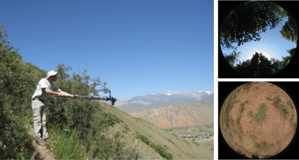
Doris Klein from the Remote Sensing Department of the University of Wuerzburg presented the derived leaf area index and albedo products for the Naryn basin which will serve as input data to the hydrological model. In addition, she introduced the newly developed fractional vegetation cover product which gives the cover fractions of bare soil, herbaceous and woody vegetation. This vegetation cover product has a high spatial resolution of 30 m for a part of the Naryn catchment and will be extended with a resolution of 250 m to the whole catchment. During field trips in summer 2010 researchers from the University of Wuerzburg will collect data to validate the remote sensing product.
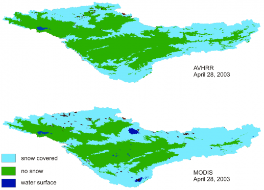
Abror Gafurov from GFZ focused his talk on snow data processing from MODIS and AVHRR data. He presented his MODSNOW algorithm to remove clouds from MODIS data sets and compared MODIS data to AVHRR snow cover data. He concluded that standard AVHRR algorithms seem to underestimate snow cover in Central Asia but AVHRR data is still needed to extend snow cover time series into the past. Snow cover will be considered in the hydrological model.
Hydrological modeling
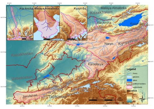
Julya Podrezova from CAIAG elaborated on the availability and quality of hydrometeorological and soil data needed for hydrological modeling. Main problems are discontinuous time series and data recorded on paper only, which have to be digitized to be used as input data. Digital soil maps for the basins of Naryn, Karadarya, Zerafshan, Ala-Archa, Kyzyl-Su and Malaya Almaatinka have been prepared by CAIAG digitizing the analogue soil maps.
Doris Duethmann from GFZ presented the hydrological model WASA set up for the Karadarya basin. A special focus was put on the regionalization of input data, e.g. precipitation. In addition, she presented an analysis of leaf area index as a function of temperature and precipitation. In a next step, a multi-objective calibration will be applied to the hydrologic model using discharge time series and satellite snow data.

Assessment of glaciers
Christoph Mayer from the Commission for Glaciology of the Bavarian Academy of Sciences presented the methods used to assess glaciated areas and glacier mass balances in Central Asia. Grey-scale SPOT images with a spatial resolution of 10 m were used to map the glaciated areas in the upper Naryn basin. For this, manual correction of the automated delineation was crucial to include debris covered ice.
David Kriegel from GFZ introduced his approach to include glacial melt in the hydrologic model WASA. He intends to test his glacier melt module in the Ala-Archa, Malaya Almatinka and Kyzyl-Suu basins. For glacier delineation he used LANDSAT images with a spatial resolution of 30 to 80 m.
During a joint expedition of the Commission for Glaciaology, GFZ and CAIAG in summer 2010, GPS techniques will be used to determine the dynamics and geo-radar measurements to assess the ice thickness of selected glaciers. In addition, the field works will help to evaluate the remote sensing based glacier delineation and provide data on debris cover.
Submitted by Katy Unger-Shayesteh on