Monitoring stations in Taragai and Kokemeren successfully installed
In summer and autumn 2010, specialists from CAIAG and GFZ installed two more hydrometeorological monitoring stations in the Naryn basin, Kyrgyzstan. The station data is transmitted every hour during summer time and once a day during winter time to the data management infrastructure SOPAF.
Details on station location and equipment:
Station | Taragai | Kokemeren |
Coordinates | 41°43'41" N 77°48'15" E | 41°50'55" N 74°20'04" E |
Elevation | 3518 m a.s.l. | 1478 m a.s.l. |
River basin | Naryn river | Naryn river |
Subcatchment | Taragai river | Kokemeren river |
Start of operation | 05-Sep-2010 | 25-Nov-2010 |
Sensors: |
|
|
GPS | + | + |
Air temperature | + | + |
Atmospheric pressure | + | + |
Rain gauge | + | + |
Snow pack analyzer | + | + |
Wind monitor | + | + |
Solar radiation | + | + |
Soil water content | + | + |
River discharge | - | will be installed in 2011 |
Seismometer | + | - |
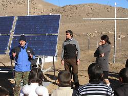
Specialists of CAIAG and GFZ introduced the newly installed hydrometeorological monitoring station at the Kokemeren river to the students of the nearby school in the village Aral.
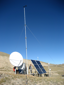
Beside hydrometeorological sensors, Taragai station integrates a seismometer delivering near-real time seismological data to the international GEOFON network.
Submitted by Katy Unger-Shayesteh on