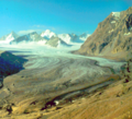
Glacier monitoring in the Tian Shan Mountains continued
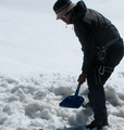
Following last year’s expeditions, a group of Kyrgyz, German and Swiss scientists continued the fieldwork on three selected glaciers in the Tian Shan mountains in Kyrgyzstan. The expedition team included researchers from the GFZ German Research Centre for Geosciences, Central Asian Institute of Applied Geosciences (CAIAG), University of Fribourg and the World Glacier Monitoring Service WGMS.
CAWa Training Course "Remote Sensing for Land Use and Land Cover Mapping"
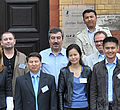
From 15th - 19th August 2011 thirteen academics from water management organisations from the region Central Asia met to participate in a training course at the German Research Centre for Geosciences (GFZ) in Potsdam, Germany. For the first time including two colleagues from Turkmenistan. The training course took place in the GeoLab, the training and education facility of GFZ. Organizers were GFZ in cooperation with the University of Wuerzburg Institut of Geography and Geology, Department of Remote Sensing.
German and Uzbek researchers collect land use data in Fergana Valley
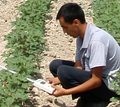
Scientists from the University of Wuerzburg, SIC ICWC and ZEU had an expedition to Fergana Valley in June 2011. They collected reference data on agricultural fields needed for the evaluation of land use classifications derived from remote sensing data. Besides, measurements of the biophysical parameter Leaf Area Index (LAI) were carried out. The expedition was supported by the German fiat panis foundation.
Rapid Eye satellite data used for research on irrigation monitoring
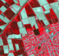
A research proposal of the University of Würzburg has been approved by the RapidEye Science Archive in March 2011. RapidEye will provide very high resolution satellite data (6.5 m) for three irrigated agricultural areas in Central Asia (Ferghana valley, Amudarya Delta, Kyzyl Orda) for the growing period in 2011 and 2012.
Web GIS with Central Asian geodata online
The demonstrator version of a web GIS with geodata on Central Asia is online accessible at http://gdbweb.caiag.kg/. The web GIS and the linked geodata base have been developed by specialists of the Central Asian Institute for Applied Geosciences CAIAG.
CAWA Electronic Learning Platform is Online

The eLearning plattform of the CAWa project is online now. Registered training participants may access the electronic course materials at http://elearning.cawa-project.net. CAWa eLearning is based on the open source software Moodle, a multilingual Learning Management System (LMS). Moodle is a platform to create effective online learning sites.
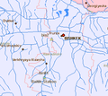
Specialists decide on the rehabilitation of Abramov station
In a workshop held at GFZ in Potsdam on March 7 and 8, 2011, specialists from CAIAG, UzHydromet, NIGMI, the Institute of Water Problems of the Academy of Sciences of the Republic of Tajikistan, and the World Glacier Monitoring Service discussed the re-installation of a hydrometeorological monitoring station at Abramov glacier in Southern Kyrgyzstan (photo by courtesy of Jury Tarasov).
CAWa Hymet Station Monitor online
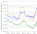
By December 2010, 5 hydrometeorological monitoring stations have been installed and connected to the regional CAWa Hymet monitoring network. Their observational data is now accessible to the public in a graphical form. To have a look at the visualized data, go to the Station Monitor.
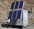
Monitoring stations in Taragai and Kokemeren successfully installed
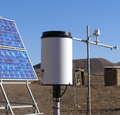
In summer and autumn 2010, specialists from CAIAG and GFZ installed two more hydrometeorological monitoring stations in the Naryn basin, Kyrgyzstan. The station data is transmitted every hour during summer time and once a day during winter time to the data management infrastructure SOPAF.
Training Course "Hydrometeorological Monitoring Network and Geodata Bases"
On December 14 -16, 2010, GFZ and CAIAG are inviting experts on geodata management to participate in the training course on “Hydrometeorological Monitoring Network and Geodata Bases”. The training will give an introduction to the sensor network and monitoring station concept as well as the data processing software architecture developed within the CAWa project